Exposure Workshop on “Use of Geospatial Technology in Governance”
3 min read
Shimla, Dec. 6 – Consequent upon the Budget Assurance of the then Government in 2011, Government of Himachal Pradesh established the Aryabhatta Geo-informatics & Space Application Centre (AGiSAC) under aegis of the HP Council for Science Technology & Environment (HIMCOSTE) in the year 2011 with the objective to institutionalize Geo-informatics Applications and ensure efficient, effective, transparent, & accountable governance in the State. Ever since its inception, the Centre has provided services to the various State Government Departments like Election, Health, Forest, Jal Shakti, Agriculture/Horticulture, Animal Husbandry, Economics & Statistics, Fisheries etc. on the role of space and geospatial technology in their planning and developmental process.
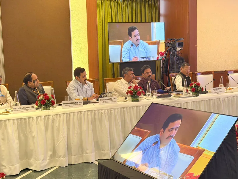
In order to further sensitise the different organs of the State Government on the scope of space and geospatial technology and its integration for easy access and data sharing amongst the user departments, the AGiSAC organised a half day user interaction meet with all stakeholder departments on the “Use of Geospatial Technology in Governance” on 6th December, 2021 in Conference Hall of Armsdale Building, HP Secretariat, Shimla, which was chaired by Sh.Ram Subhag Singh, Chief Secretary, Government of Himachal Pradesh. In the interaction meet, Dr. Parkash Chauhan, Director Indian Institute of Remote Sensing (IIRS) Dehradun, (DoS-ISRO) Govt. of India and Dr.B.K.Badhra, Dy.General Manager , Regional Remote Sensing Centre-North from Delhi were invited as the special guest to talk on the role of space technology in the Governance System. Besides these, the Administrative Secretaries of various line departments, HoD’s and Senior Officers of different Departments/Corporations/Boards participated in this workshop in physical , whereas the Deputy Commissioners, ADMs, Deputy Directors, General Managers Industry SDMs, BDOs, DFOs and ULBs officers also participated in this workshop virtually. Sh.Sudesh Mokhta , Member Secretary ,HP Council for Science Technology & Environment welcomed the Chief Guest, Guests and the Heads of Departments of the State to this half day interaction meet.
Sh.Prabodh Saxena, Additional Chief Secretary (Environment, Science & Technology) in his address informed that AGiSAC has developed a good human capacity over the years in various sectors of development in the hill state like that of Himachal Pradesh, wherein the space and geospatial technology can play a crucial role in its planning process. He stressed that all stakeholder department must introduce this technology in their planning process and also desired that all their natural resources and infrastructure database should be created in the GIS environment for effective e-governance in the state.
While inaugurating the half day interaction meet, Sh.Ram Subhag Singh, Chief Secretary, Government of Himachal Pradesh said that space technology derived inputs along with geospatial technologies and field information are being adopted in an integrated way by various Central Ministries and State Governments in planning, periodic monitoring, mid-course correction and evaluation of developmental activities, which would help in for better monitoring of the time schedules and ease in the management of financial allocations of the Public Benefit Schemes. Referring back the Budget Assurance in 2011, he informed that the Government will take up to Notify the AGiSAC as the Nodal Agency in the State for implementing the mandate of the Geospatial technology in the Governance system for the planning, decision making and monitoring of various developmental activities in the State for all its stakeholder departments and suggested that all the departments should make use of this technology in their planning, developmental and monitoring process through AGiSAC, so that the public programmes/schemes could be implemented in proper and more better scientific manner.
During the technical sessions, two expert speakers Dr.Prakash Chauhan Director IIRS Dehradun and Dr.B.K.Badhra from RRSC New Delhi made a detailed presentation on the Geospatial Technologies for Governance and Service Delivery and Use of Geospatial Technology in Governance and highlighted the potential of the these technology in the governance system. Sh. Sudesh Mokhta (Member Secretary), HIMCOSTE gave the brief introduction of AGiSAC and also explained to the participants about the importance and potential of the AGiSAC. He also thanked the participants for giving their precious time for this workshop. Sh.Satpal Dhiman, Joint Member Secretary also made a presentation in which he highlighted the various services which have been provided by AGiSAC during the past since 2011 and its further potential in the state for having joint projects with other stakeholder departments for the successful implementation of the technology.